Autumn colours at Lake Saimaa - even better than Lapland
September 3, 2025
Blog
Sometimes you don’t need to travel to the ends of the Earth to find the best vacation spots. In Mikkeli region you can find stimulation for all the senses while admiring the vibrant colours of autumn. Fresh, crispy air of a bright autumn day, a warm drink in your thermos bottle and a packed lunch in your backpack is all you need for a pleasant day of hiking along one of our many beautiful nature trails. Here are some tips for interesting hikes and scenic spots in the Mikkeli area, both near urban centres and far from the city, in perfect peace of the Finnish forests.
Hiijje Silmukka and Hiidenkierros at Neitvuori in Anttola
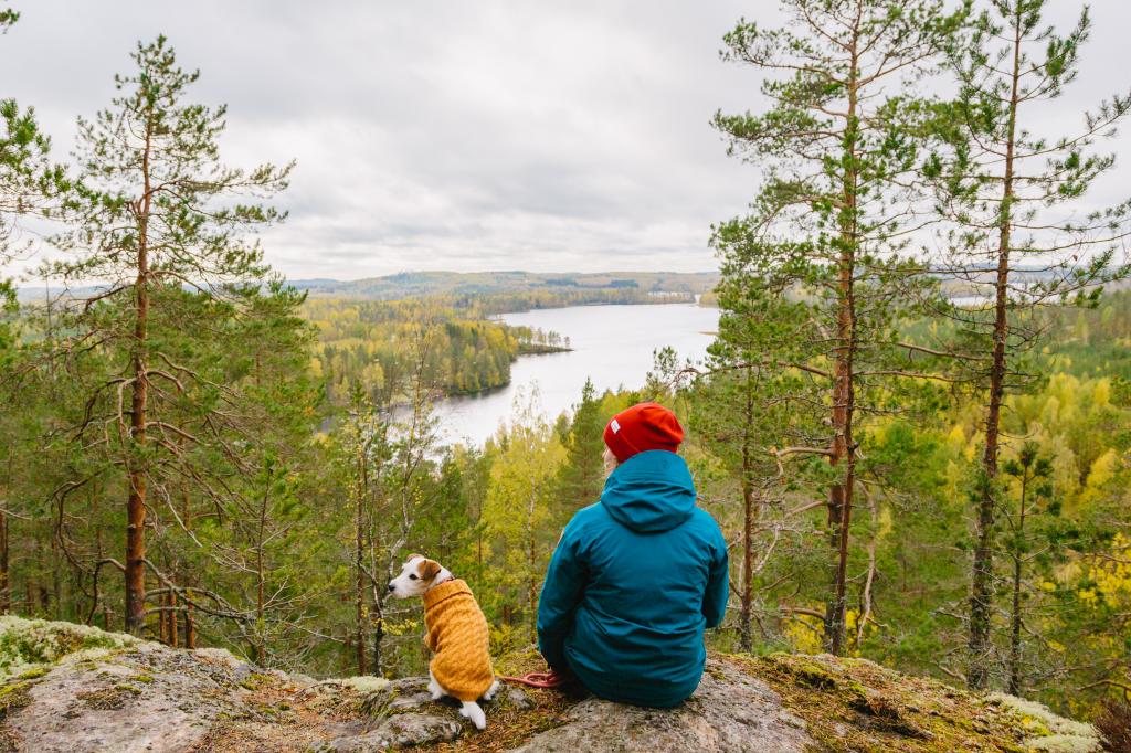
Neitvuori is a small mountain that rises up to 184 m and offers some of the best views in the area overlooking Lake Saimaa. On a clear autumn day hikers can witness the bright oranges and the deep greens of the forest contrasting with each other as the Luonteri archipelago spreads around them.
From the top of Neitvuori one can see Luonteri archipelago stretching out for miles.
The main hiking routes at Neitvuori are marked with different colors, making it easy for travelers to follow along their chosen path. The Hiijje Silmukka trail (orange markers) can be taken either as a short 2,5 km long hike or a longer 4 km hike. This trail takes the travelers all the way to the top of Neitvuori. Hikers can get to Hiijje Silmukka from the parking lot located next to the nearby Hiidenmaa farm.
More enthusiastic hikers can take the blue makers deviating away from the Hiijje Silmukka path to the approximately 12 km long Hiidenkierros path. This trail is also suitable for mountain biking. Both trails feature many wonderful scenic spots and also rest areas, some of which come with a fire pit where travelers can enjoy their packed lunches or a stop for a cup of coffee roasted on an open fire. Along Hiidenkierros one can also rest at the Hiidenkota shelter.
For experienced hikers and those looking for a challenge, it is possible to continue from Hiidenkierros to a 10 km path going to Pitkäjärvi laavu-shelter, to a 25 km path going to Siikakoski in Juva, or even to a 55 km long Metsäväkitaipale path. Along Metsäväkitaipale is an natural rock formation consisting of some glacial erratics and cave called Enkelinpesä (”Angel’s Nest”), named after the humanoid-looking winged figures that are visible on the surface of the rocks. There is a rest spot at Enkelinpesä with a fire pit and benches.
Tip to those seeking for a truly immersive nature experience: There are many experienced guides available in the area who are happy to help you explore the scenic treasures of the Finnish Lakeland, such as Guide Tiina operating in the Anttola and Puumala region.
Reaching Neitvuori
From the Village of Anttola there is an about 20 km drive to Neitvuori. Coming from Mikkeli, one must take a left turn from route 62 before Anttola to Kokkosenlahdentie road. After this, continue along Ylivedentie road and then take the Neitvuorentie road. There are signs guiding visitors to the top of the mountain. Neitvuori can also be reached by boat, as there is a landing spot near the mountain at Hiidenlahti pier.
Sydänmaa hiking trail in Anttola
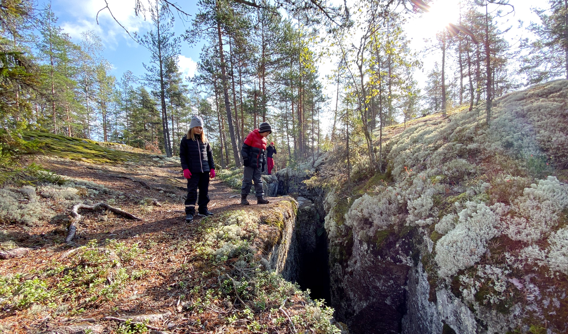
Sydänmaa hiking trail is a 5 km long route in Mikkeli’s Anttola that twists its way along forest paths and up ancient cliffs and rocks. Along the route is Rakokallio fissure, an impressive natural formation that stands as a testament to the regions unique geolocical history. This Saimaa GeoPark destination originates from almost two billion years ago, when tectonic tension caused the rocky ancient seabed to rise and form mountains. Over millions of years erosion caused these ancient mountains to wear down and eventually these mountains became different types of cliffs and rocky hills. As tectonic plates continued to collide the surface rock started to crack, leading to the formation of fissures such as Rakokallio.
Fissure going deep into the rock like this is a rare natural phenomenom.
Rakokallio fissure is about 100 m long and at its depth reaches 10 m at the deepest spot. The bottom of the fissure is partly traversable, but the path forward is blocked in various places by large rocks. There are narrow caves under some rocks that are difficult to navigate. It is possible enter the fissure from both ends.
Rakokallio is a protected area, so one cannot build a fire or set camp there. There is a resting spot at nearby Mäkilampi lake where travelers can find a fire pit and spend the night at the laavu-shelter there. Metsämäki scenic spot near the laavu offers excellent views of the surrounding area.
Visitors to Rakokallio are advised to take into account the potentially perilous terrain near the fissure, especially during rainy and snowy weather when the ground around the edges of the fissure may be slippery. There is also a shooting range near the hiking trail, so it is recommended that hikers not leave the marked path.
Reaching Sydänmaa hiking trail
From route 62 take the Sydänmaantie road near Anttola village and there take an immediate left to Sipiläntie road. Continue along this road for 1,1 km, after which take a right turn. Continue forward for 1,6 km and you will reach your destination.
Saimaa archipelago is breathtaking also in autumn
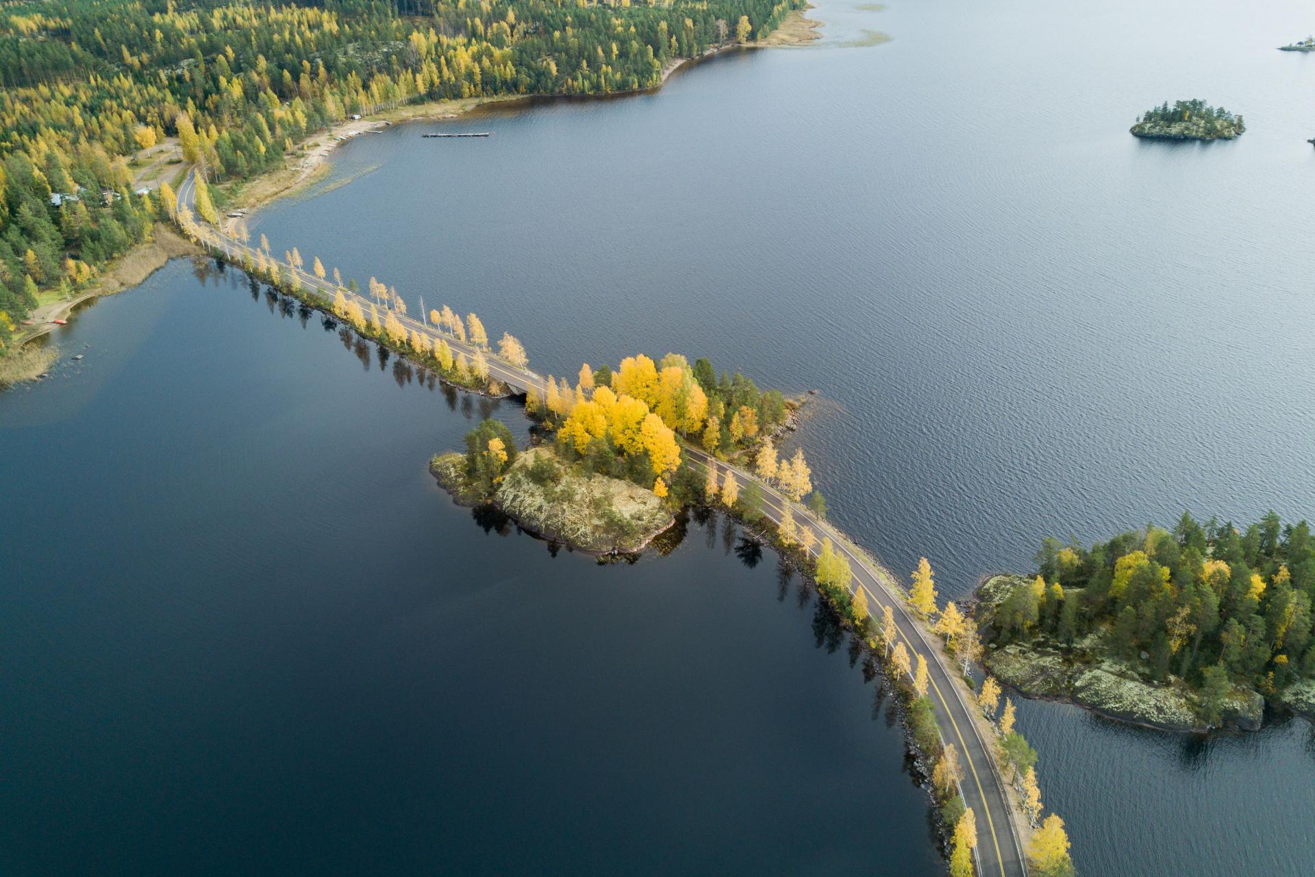
In the Puumala region one can admire the beautiful nature of Lake Saimaa in glorious autumn colours. Lietvedentie road between Mikkeli and Puumala is popular among cyclists and offers fantastic views of the Saimaa archipelago, as do many other roads in the area. Visitors planning to take a scenic tour in Puumala are advised to take note that the ferry connection between Lintusalo and Hurissalo that is along the popular Puumala archipelago route does not operate during winter season, but everything else is accessible year-round.
Lietvesi scenic roads twists its way through the islets of Lake Saimaa.
From Puumala centre nature lovers can access Norppapolku path, a 13 km long scenic route that travels in coniferous forests, along beaches and over rocky outcrops and other terrain typical of the Finnish Lakeland. The path is well marked and on the route one can find a fire pit, a restroom, a water spot and a charming laavu-shelter.
Elsa Heporauta path can be accessed from Sahanlahti Resort and Hylkeenlahti rest stop. Depending on where one starts, this path either 22 or 24 km long and it is suitable for both hikers and cyclists, as it consists mostly of gravel roads and forests paths.
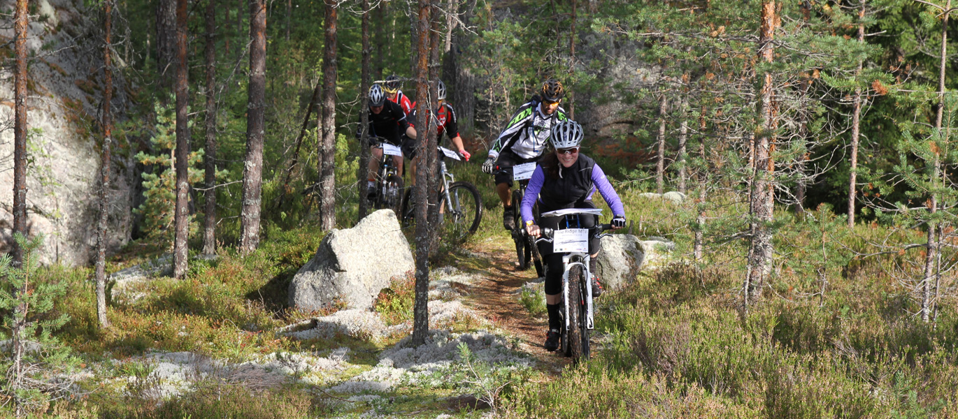
Those looking for longer cycling routes can challenge themselves with the annual Luonteri Cycling event’s routes. These include the 40 km long ”Heken Lenkki” and the tough, hilly, 95 km long ”Savon Sveitsi” (”The Switzerland of Savo”). Both routes travel around Luonteri archipelago through forests and local villages, so there’s plenty of variation in the scenery along the way. The roads along the routes are either asphalt, gravel, sand or crushed stone.
Along the longer Savon Sveitsi route there is a ferry crossing at Kuponvirta that offers an excellent change to take a brief rest and enjoy the scenery of Lake Saimaa. On the route cyclist can also take a break at Karihiekka beach, where its also possible to make a fire in the designated spot. Those wanting to get a better view of the lake can climb up to Kaara- Kuva- or Rapiovuori mountains.
A suitable start and finish point for this cycling route is Saimaanranta Resort by Anttolanhovi, where one can find accommodation, a restaurant and even an indoor pool area and a sauna for travelers wanting to relax and rest their weary muscles after a long journey.
Repovesi National Park calls hikers, cyclists and paddlers
From Mäntyharju centre there are trails for hikers and cyclists and that travel through varying forest terrain towards Repovesi National Park. There’s plenty to see along the route, such as rocky hills, lakes and ponds and even rock art.
Cycling on forests paths provides variety to a trip taken along main roads.
The hiking trail leaving from Mäntyharju is about 33 km long and traversable during all seasons. However, it is worth noting that during bad weather the more challenging parts of the trail may be slippery and more difficult to travel. The hiking trail is marked with orange markers. Along the route one can find several interesting natural and historic sights, as well as rest spots approximately every 10 km.
The cycling trail from Mäntyharju to Repovesi travels along forest paths and roads. The starting section of the route is considered easy and suitable for less experienced cyclists, but nearer the national park the route is more challenging. The cycling trail is marked with blue signs, but those wishing to make a circle trip from Mäntyharju to Repovesi and back are advised to use a GPS-locator between Lapinsalmi parking lot and Orilampi. It is also worth noting that inside the national park one can only ride a bike on the service roads.
The Mäntyharju-Repovesi hiking and cycling routes utilize partly the same trails, so visitors should pay attention on the colours of the signs on the places where the paths converge and separate.
Whether one chooses to hike or take a bike, it is possible to make the trip with multiple stops. There are suitable places to spend the night about every 20 km along the routes, as well as several laavu-shelters with fire pits about every 10 km. Matkosmäki laavu-shelter also has a wood-heated sauna visitors can use. Travels can spend the night free on any laavu-shelter without reservations. For those looking for a bit more comfort along their trip, old Linkkumylly farm and mill offers accommodation in cosy cottages.
It is also possible to reach Repovesi National Park by paddling. The paddling route from Mäntyharju to Repovesi is about 50 km long and has many interesting sights along the way, such as picturesque islands, historic landmarks and even rock art. There are landing spots and places for spending the night about every 15 km. The route is suitable for inexperienced paddlers, but on the open water sections there can sometimes be strong winds that significantly effect travel time.
Travelers wishing to take the paddling route are advise to note that there is a portage section on the route at Voikoski. This section can only be traversed in the north-south direction. Landing at Voikoski can be challenging due to the currents from Voikoski power station lock gates.
Getting to the Repovesi trails from Mäntyharju
Both the hiking and cycling trail leave from Kisala sport hall’s parking lot at Urheilutie road in Mäntyharju. From Mikkeli travelers can reach Mäntyharju by car, bus or train. Kisala sports hall is about 1 km away from Mäntyharju train station. The start of the paddling route is at Kurkiniemi right next to the train station.
Nature experiences right in the city
In Mikkeli there are nature paths and hiking trails waiting for travelers just a stone’s throw away from all the comforts civilization can provide. Here are some examples of scenic trails in Kangasniemi, Juva and Mikkeli that are within a walking distance from urban centres.
Suurola nature trail near Kangasniemi centre
Suurola nature trail is located about 4 km from Kangasniemi village. This 4 km long trail goes around Suurolansaari cape and consists mostly of sand roads, forest paths . There are also a couple of sections with duckboards.
There’s plenty to see along the trail, such a birdwatching tower, a pier, a kota-shelter with a fire pit, a forest church and quite a few interestingly shaped glacial erratics. Along the route travelers can also find 27 signposts with information about local flora and fauna.
This trail is accessible from Ketonkolontie road and also from the parking lot in Telkonlahdentie road, where there’s also a guide map.
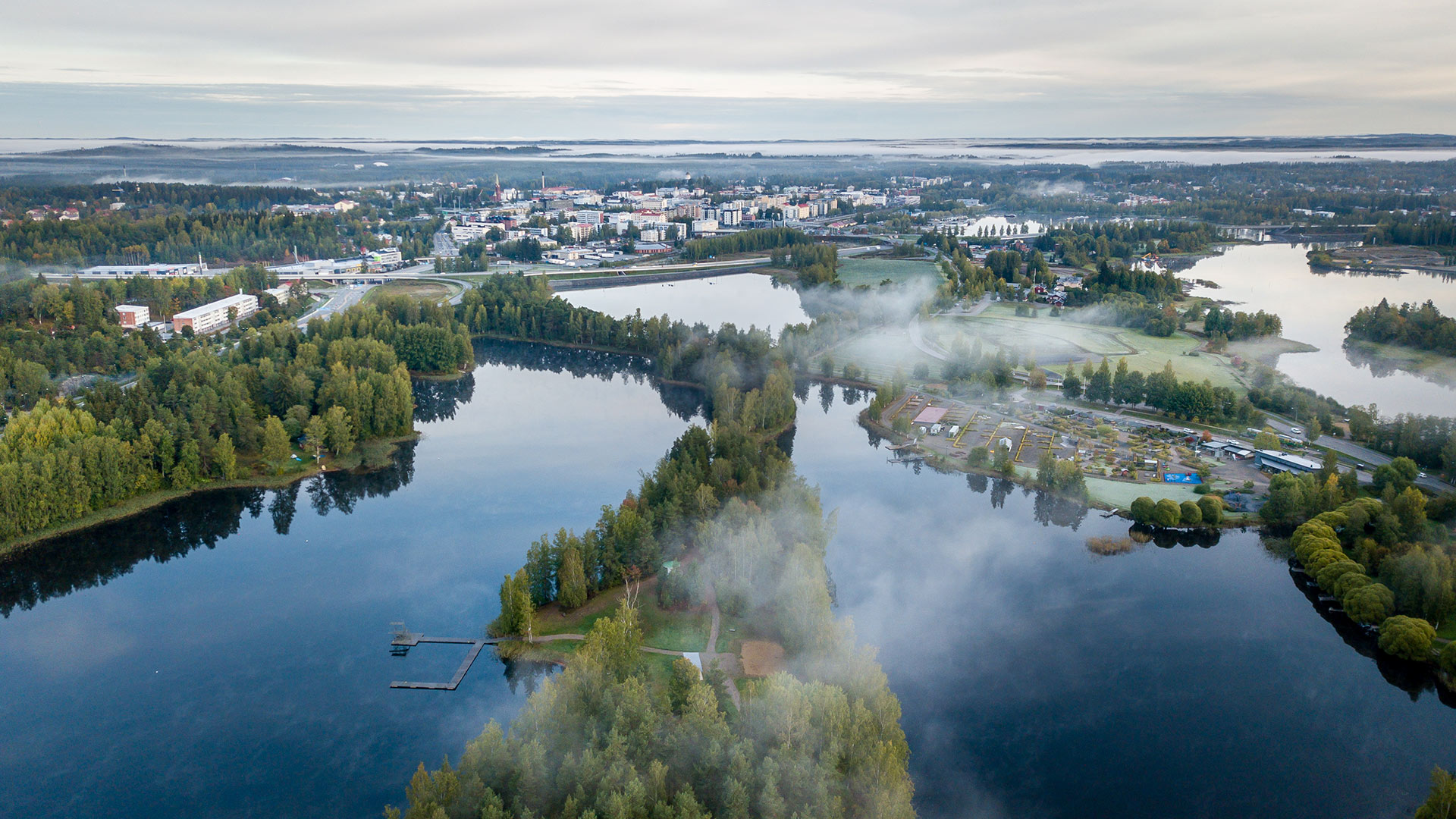
Explore Lakeland nature without leaving Mikkeli Centre
Autumn colours are on display at Mikkelipark and its surroundings, located only few minutes away from Mikkeli centre.
At Urpola Nature Centre visitors can find a cosy nature path suitable for the whole family. This path travels alongside a river and winds past an old mill, offering a taste of old-fashioned rural charm right in the city.
Kaihun Kierros is a 2,5 km long path that travels through boreal forest scenery near the shores of Lake Saimaa. This trail is suitable for all ages and after a refreshing hike the visitors can enjoy shopping and refreshments at the old Kenkävero vicarage.
Kaihun Kierros is a piece of Finnish Lakeland right in the heart of Mikkeli.
Gottlund route in Juva provides both nature experiences and a look into local history
Gottlund route in Juva village is a 9 km long walking trail suitable for all ages. Along the route one can find beautiful natural sights, culturally significant spots, a beach suited for a swimming break and a rest spot with a fire pit for enjoying a picnic. This diverse path starts from Partala manor, circling around Huttula vicarage and alongside the shores of Jukajärvi and Salajärvi lakes. Along the path there are 25 signs market with a clover that provide information about local history, sights and nature.
Gottlund route is named after Kaarle Akseli Gottlund (1796-1875), a Finnish explorer and historian who lived in Juva in his early age. Part of the route travels past his childhood home, near which one can also find Juva’s old graveyard and an old windmill.
More nature trails in the Mikkeli region
Mikkeli abounds with nature trails, each more beautiful than the other. Read here for more information on scenic paths and hiking trails in Mikkeli region.
Get to know Mikkeli in autumn
There are plenty of options in the area for a wonderful autumn break. Whether just looking for a pleasant day out or planning stay longer in the region, Mikkeli offers everything from activies and sports to culture and history for visitors to explore. Learn more by checking out our section all about autumn and winter in Saimaa.
Flavors of Mikkeli on your plate and in your souvenir basket
Create fond memories and take a little piece of your autumn vacation with you when you go with delicious food sourced directly from the forests and lakes of the Saimaa area.
Sahanlahti Resort offers delicious food made from local ingredients in their restaurants.
Ollinmäki Winery in Anttola brews and sells wines and ciders made from Finnish berries and fruits.
At Kenkävero visitors can dine in the atmospheric old vicarage and also buy delicious local products from the vicarage's shop.
Mikkeli's Tertti Manor offers seasonal menus featuring the best ingredients of the region and well as produce from the manor's own garden. The manor shop also sells treats and preserves.